
It should be obvious that if all you have is a sedan, you probably won’t be moving any furniture. Likewise, if all you have is a 2-seater car or pickup truck, you won’t be taking any extra people with you on a road trip. Households that have multiple vehicle types are far more flexible with what they can do. While I only have a hatchback car, I also have an electric scooter and make great use of that for short errands, saving gas and maybe polluting the planet just a bit less than driving my car would.
The same can be said about operating systems, whether than be a desktop computer OS such as macOS, Windows or Linux, or a mobile operating system such as Android, iOS, or iPadOS.
During my days as a Windows PC user, all I could run was Windows stuff. Linux became a thing, allowing folks like me to dual-boot and take advantage of a world of open source software plus Windows software. I never ran Linux on my Toshiba laptop, but I did dual boot into Microware OS-9000 (but that’s a story for another time).
I really learned the value of running more than one OS when I switched to Macintosh in 2001. I was suddenly able to run a new (to me) world of Mac software, as well as continue to run all my Windows programs via Connectix’s Virtual PC emulator (later Microsoft Virtual PC). I gained so much by being able to run the Mac stuff I wanted, and still have access to Microsoft Money or PC-only development tools like BASIC Stamp and such.
Google Maps versus Apple Maps
All this to say … right now, iPhone users may have a map advantage. I generally use Google Maps for the majority of my searching, but over the years I have found a number of cases where the Apple Maps satellite view is more up to date than what Google has. For instance, up until recently, Google Maps was showing the Lost Island Theme Park in Waterloo, Iowa as a large patch of dirt — even though the park had been open five years.
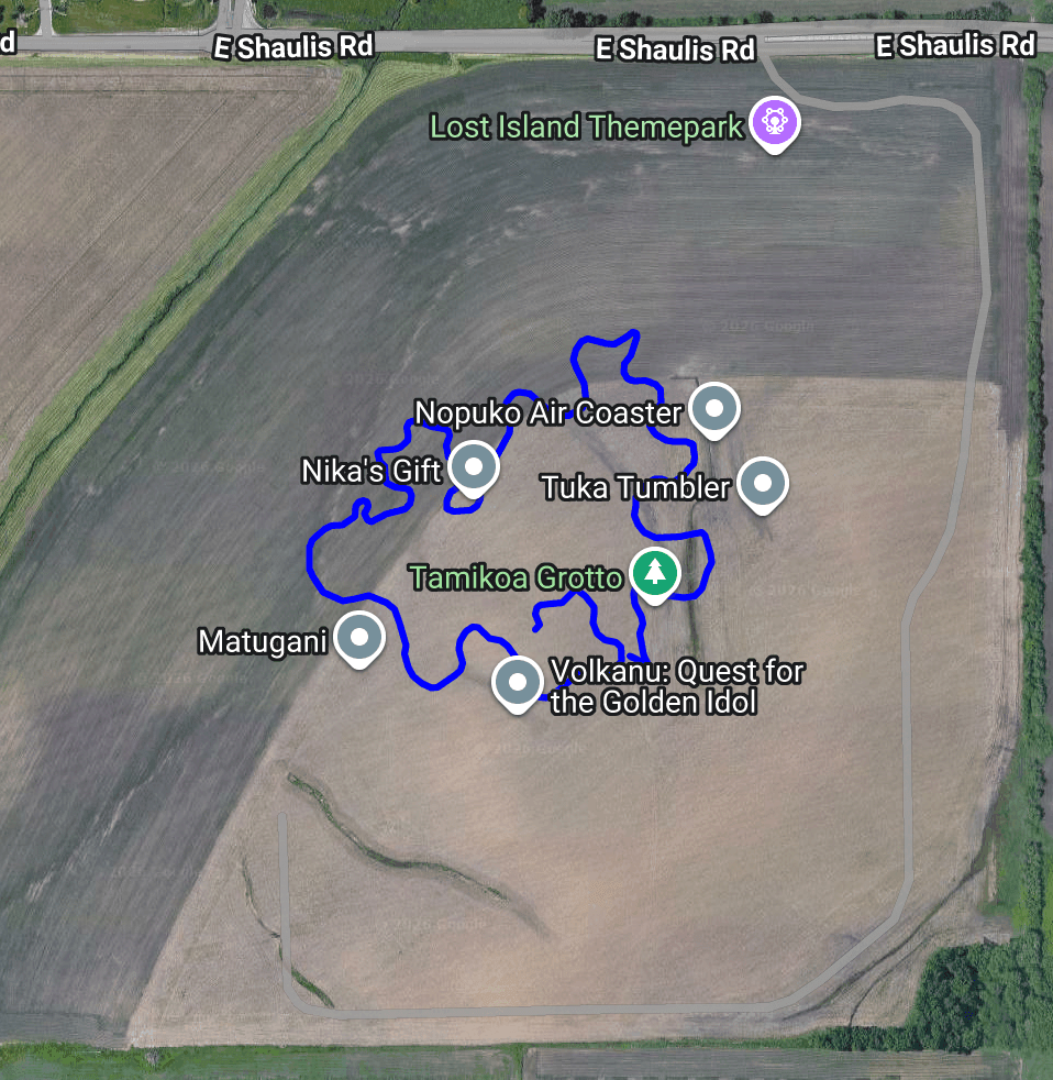
Meanwhile, Apple Maps was showing the park built out, though not updated enough to have the new roller coaster they added last year.

Had I only used Google Maps, I’d still be looking at dirt. (NOTE: The top screen shoot from Google was created on July 22, 2026 — it shows dirt because this is the image Google uses for their Street View upload site. If you go to maps.google.com you can see their more updated image that shows the park there.)
There are likely many examples where the other case is true and Google Maps has more updated aerial imagery.
All this to say … if you use an iPhone, you should have Google Maps installed in addition to Apple Maps. If you use an Android phone, there is no Apple Maps app available, but you can at least access it via the web browser at https://maps.apple.com
Don’t limit yourself. You can have more capabilities ;-)
And all you Open Street Maps fans can comment away telling us how much better than is than either of these choices.
Weirdly Bing maps isn’t available either as an Android or iOS app!
Also: A sad thing is that some local/regional map services in Europe seems to have closed down, or rather switched to using openstreetmap data and removed aerial photos. Not that many years Sweden and to some extent neighboring countries had two separate local/regional maps, called Eniro and Hitta, which both had their own aerial photos and whatnot.
I assume default installed map apps on smartphones killed these. Surprising that no EU regulations mandated that phones came with multiple options where the user would have to choose which one(s) to use.
Wow, I completely spaced BING Maps! They had sat footage of some areas where I live before Google many years ago.